El Niño Winter Forecast 2026–27: Snow and Snow Days by City
A very strong El Niño is likely. In the three like it since 1991, 178 of the 223 cities we compared got less snow than usual, and Denver got more. Look up 296 cities.
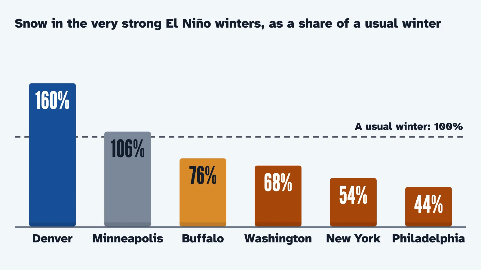
A very strong El Niño is likely this winter, and NOAA’s outlook favors a warmer than average North and a wetter South (NOAA). In the three very strong El Niño winters since 1991, 178 of the 223 cities on our map we could compare got less snow than in their other winters, in our count of NOAA’s daily station records (ACIS).
The Northeast came up short almost everywhere, while Denver, Reno and Albuquerque got about 1.5 to 1.7 times their usual snow. Days with enough snow to close schools, by our rule of thumb, came half to nearly three-quarters as often as in a usual winter (ACIS).
Three winters are not a forecast. NOAA does not forecast seasonal snowfall, each of those winters had its own surprises, and this El Niño may end up stronger than all three. Find your city below, and use the calculator when a storm is actually on the way.
How strong is this El Niño?
Very strong, and possibly the strongest since 1950, as far back as NOAA’s records of it go. On October 8, NOAA’s Climate Prediction Center kept its El Niño Advisory in force and said a strong to very strong El Niño was likely through January to March 2027, with a greater than 83% chance (CPC).
The usual measure, the Niño-3.4 index of sea temperatures in the east-central tropical Pacific, had reached 2.1°C above normal over the past month by October 8 (CPC) and 2.4°C in the latest week by October 15 (CPC).
The Center’s strength odds use another measure, its Relative Oceanic Niño Index, which sets the same waters against the tropics as a whole (CPC’s El Niño table). On it, the Center gives an 81% chance of 2.0°C or more, the very strong range, for December to February (ENSO strength odds). It put the chance of 2.5°C or more, stronger than any El Niño since 1950, at 83% for October to December (CPC). Two forecast tools the Center uses put the peak in November to January, near 3.0°C and 3.5°C (CPC).
How strong: El Niño at its peak
NOAA’s Relative Oceanic Niño Index, °C
1982–83 Before the 30 winters our snow counts cover
+2.40°C
1991–92
+2.12°C
1997–98
+2.28°C
2015–16
+2.25°C
Jul–Sep 2026 This El Niño, the latest value on November 1
+1.69°C
2026–27 peak Two forecast tools NOAA uses, November to January
About +3.0 to +3.5°C
A stronger El Niño makes its usual effects more likely, not certain. The Center says an event this size raises the chances of impacts consistent with El Niño, though they are not guaranteed (CPC), and that strength “does not necessarily correspond with the strength of the influence” (ENSO strength odds).
NOAA’s index data shows four very strong El Niños since 1950, and 1965–66 and 1972–73 fell just short, at 1.99°C and 1.97°C (RONI data). The oldest of the four, 1982–83, came before the 30 winters of station records we use.
What does NOAA’s winter outlook say?
Warmer north, wetter south. NOAA’s outlook for December to February, issued October 15, expects a very strong El Niño to shift the jet stream south and east (NOAA). It favors warmer than average temperatures across the northern U.S., and wetter than average conditions across the southern U.S., from California to Florida, and along the Eastern Seaboard (NOAA).
For November to January, the Climate Prediction Center’s discussion puts the best odds of warmth from the Pacific Northwest to the northern Plains, the Great Lakes and the interior Northeast (CPC). It favors a drier than normal season in the northern Rockies and parts of the Great Lakes, and a wetter one from California and the Southwest across the central and southern Plains to the Southeast and up the Eastern Seaboard (CPC).
Where the storms go
- Storm track in a strong El Niño winter
- Storm track in a usual winter
- Warmer than average favored
- Wetter than average favored
What the outlook does not do is forecast snow. NOAA says it “does not project seasonal snowfall accumulations,” and that snow forecasts are generally not possible more than a week ahead (NOAA). By our reading, warmer odds lean against snow in the North, while a wetter South can mean snow where storms meet cold air. The past winters show both.
Did past El Niño winters bring less snow?
In most places, yes. We added up each winter’s snowfall in NOAA’s daily station records for the 296 cities on our map and set each city’s three very strong El Niño winters against its other winters from 1991–92 to 2020–21 (ACIS). We left out 46 cities where a usual winter brings under 2 inches, too little to compare, and 27 whose records are too incomplete. Some neighboring cities share a station’s record.
The map stands a column on each of the other 223, as tall as its El Niño snow as a share of a usual winter. The buttons under it switch between the three winters, which went quite differently.
Snow in the very strong El Niño winters: All three
- Under 70%
- 70 to 89%
- 90 to 110%
- 111 to 130%
- Over 130%
- Snow is rare
- Records too incomplete
In the three winters together, 178 of the 223 cities we could compare had less snow than usual, 22 about the same and 23 more.
By our reading, the shortfall fits the warmer North that NOAA describes. In our count, the Northeast had less snow in 53 of its 54 cities, the Pacific Coast in all 6 we could compare and the Midwest in 38 of 48, with none there getting more (ACIS). The South had less in 42 of 52. The Mountain West split: 15 cities had less and 13 more, most of them along Colorado’s Front Range, around Reno and in New Mexico.
Could three ordinary winters do the same? We ran the same count for every other set of three winters from those 30 years, 2,925 sets in all. In the middle set, 37% of the cities had less snow than usual. Only 65 sets left as large a share short as the El Niño winters did, 178 of 223 (ACIS).
No two of the three winters were alike. In 1997–98, New York got 5.5 inches, 17% of its usual snow, and Washington, D.C., a tenth of an inch (ACIS). In 2015–16, New York’s Central Park record shows 27.3 inches on January 23 alone, and the city ended that winter at 103% of usual, Washington at 157% (ACIS). A strong El Niño tilts the odds, and one storm can still make a winter.
How much snow did your city get in El Niño winters?
Pick a state and a city. The card sets its usual winter, the average of its other winters with a full record, beside each of the three El Niño winters, and counts the days with enough snow to close schools there about half the time, by our rule of thumb.
Your city in El Niño winters
New York, New York
54% of a usual winter’s snow, on average, in the three very strong El Niño winters
Usual winter: the average of the city’s other 27 winters from 1991–92 to 2020–21 with a full record. Days: days with 5 inches of snow or more, about what closes schools here half the time by our rule of thumb.
- Record
- New York-Central Park Area (NYCthr), the city’s long-running record; main station 4.5 miles away.
From NOAA’s daily station records through ACIS. Each winter runs July 1 to June 30 and counts only with a record on at least 90% of the days from September 1 to April 30. Three winters are no promise for this one.
Beyond the cities in the picture at the top, Chicago averaged 73% of a usual winter’s snow in its 2 El Niño winters with a full record, Pittsburgh 62%, Kansas City 66%, Milwaukee 79% and Indianapolis 47% (ACIS).
Snow comes early or late in an El Niño winter too. For when the first measurable snow usually falls in your city, see our first snow dates for 296 cities.
Will there be fewer snow days this winter?
Past El Niño winters suggest fewer chances, not none. By our rule of thumb, schools close about half the time when a day’s snowfall reaches a point set by how much snow a place usually gets: half an inch where snow is rare, up to 15 inches where it is deep (how much snow closes school). We counted the days that reached it at each city’s station (ACIS).
Days with snow enough to close schools
- In that winter
- Short of a usual winter
1991–92 115 days across 213 cities, 50% of a usual winter’s 229
1997–98 146 days across 207 cities, 64% of a usual winter’s 228
2015–16 174 days across 222 cities, 72% of a usual winter’s 241
Not everywhere: in 54 of the 223 cities, the El Niño winters averaged more such days than a usual winter.
Denver is one of the exceptions: its El Niño winters had 1, 3 and 1 such days, against about 0.4 in a usual winter. Colorado Springs and Reno also had more in every El Niño winter with a full record (ACIS).
A day’s snowfall is not a school’s decision. Timing, ice and cold count too, and only your district decides, so check its website, app or local TV and radio. When a storm is in the forecast, the calculator gives the chance of a snow day at your ZIP code from the National Weather Service forecast.
Where did El Niño winters bring more snow?
Along the Rockies’ eastern edge, around Reno and in parts of the South. Colorado Springs averaged 159% of its usual snow and Albuquerque 147%, and Reno 166% in its 2 El Niño winters with a full record (ACIS). Our count shows where it happened, not why.
Where snow is rare, one storm stands out. Atlanta, whose usual winter brings 1.8 inches, got 5 inches on January 18, 1992, and Jackson, Mississippi, got 4.8 inches on December 14, 1997 (ACIS). Nashville averaged 119% of its usual 4.5 inches, mostly from 11.3 inches in 2015–16 (ACIS).
Will the polar vortex bring cold this winter?
For the season as a whole, NOAA’s forecasters see the odds tilted slightly against it, but a disruption may be coming in early November. The polar vortex is a large area of low pressure and cold air around the pole, and when it expands in winter it can send cold air south with the jet stream (NWS).
The forecasters write that the vortex is typically stronger and more stable during El Niño and the westerly phase of the Quasi-Biennial Oscillation, and both are in place this winter (CPC). A steadier vortex, they write, slightly lowers the odds of sudden stratospheric warmings and the negative Arctic Oscillation spells that may follow. They call that supportive of warmer than normal temperatures in the mid-latitudes in general, and in line with their forecast for the northern and eastern U.S. (CPC).
Slightly lower odds are not none. On October 31, the forecasters wrote that computer models show a possible disruption of the polar vortex in the first week of November, perhaps turning into a sudden stratospheric warming, which they call very rare in November (CPC). If it happens, they write, its effects can last up to 2 months, usually as a negative Arctic Oscillation, which could mean cooler periods and adds uncertainty most of all in the eastern U.S. (CPC).
The forecasters also note one difference from the past: the Pacific Decadal Oscillation is in its negative phase, while 1997–98 and 2015–16 both came in its positive phase, though they judge its influence this winter may be minimal (CPC).
El Niño and your snow
- This El Niño
- very strong likely
- may top any since 1950
- peak Nov to Jan
- NOAA outlook
- warmer North
- wetter South and East Coast
- no snowfall forecast
- Past very strong El Niños
- less snow in most cities
- Northeast nearly all
- each winter different
- More snow
- Denver
- Reno
- Albuquerque
- Snow days
- fewer in most cities
- one storm can change it
- Polar vortex
- steadier in El Niño
- a November disruption possible
Questions people ask
Does El Niño mean less snow?
In most U.S. cities it has. In the three very strong El Niño winters from 1991–92 to 2020–21, 178 of the 223 cities we could compare averaged less snow than in their other winters (ACIS). Denver, Reno and Albuquerque averaged more, and one storm can still bring a big snow, as New York’s 27.3 inches in a day in January 2016 showed.
Will winter 2026–27 be snowy?
Nobody can say yet. NOAA does not forecast seasonal snowfall; its outlook favors a warmer than average northern U.S. and a wetter South (NOAA). By our reading of the past very strong El Niño winters, that leans toward less snow in the North and Northeast and more along Colorado’s Front Range, but each of them went its own way.
Is this the strongest El Niño ever?
It may be the strongest since 1950, as far back as NOAA’s index goes. On October 8 the Climate Prediction Center put the chance of 2.5°C or more on its index, stronger than any El Niño since 1950, at 83% for October to December (CPC). The strongest in NOAA’s index data so far reached 2.40°C, in December 1982 to February 1983 (RONI data).
Does El Niño mean a mild winter in the Northeast?
The odds lean that way. NOAA’s forecasters favor warmer than normal temperatures in the interior Northeast for November to January (CPC), and in the past three very strong El Niño winters, 53 of the 54 Northeast cities we compared had less snow than usual (ACIS). Odds are not a promise, and cold snaps still happen in warm winters.
When does NOAA update its winter outlook?
The Climate Prediction Center issues its next seasonal outlooks on November 19, 2026 (CPC) and its next El Niño discussion on November 12 (CPC). Forecasts of actual snow come only days ahead, from your local National Weather Service office.
Every city’s El Niño snow
All 296 cities: the usual winter, each very strong El Niño winter and the three together as a share of usual, with the station record each comes from.
Snow in the very strong El Niño winters, 296 cities, from NOAA daily station records
Show all 296 cities
| City | Usual winter | 1991–92 | 1997–98 | 2015–16 | The three, share of usual | Record, distance |
|---|---|---|---|---|---|---|
| Alabama | ||||||
| Huntsville | 2.1 in. | 0.2 in. | 2 in. | 0.4 in. | 41% | Huntsville Area, 10.8 mi |
| Mobile | 0.2 in. | 0 in. | 0.1 in. | 0 in. | Snow is rare | Mobile Area, 6.7 mi |
| Birmingham | 1.4 in. | 4.4 in. | 1.7 in. | 0 in. | Snow is rare | Birmingham Area, 4.1 mi |
| Montgomery | 0.5 in. | 0 in. | 0 in. | 0 in. | Snow is rare | Montgomery Area, 10.4 mi |
| Tuscaloosa | Records too incomplete to compare | Bessemer 3 Wsw, 33.3 mi | ||||
| Hoover | 1.4 in. | 4.4 in. | 1.7 in. | 0 in. | Snow is rare | Birmingham Airport, 12.7 mi |
| Alaska | ||||||
| Anchorage | 79.2 in. | 99.7 in. | 56.5 in. | 38.3 in. | 82% | Anchorage Area, 8.2 mi |
| Fairbanks | 63.3 in. | 98.7 in. | 45.1 in. | 60 in. | 107% | Fairbanks Area, 5 mi |
| Juneau | 90.4 in. | 93.2 in. | 35.6 in. | 34.9 in. | 60% | Juneau Area, 1.2 mi |
| Wasilla | Records too incomplete to compare | Eagle River 5 Se, 20.6 mi | ||||
| Sitka | Records too incomplete to compare | Hidden Falls Hatchery, 20.3 mi | ||||
| Ketchikan | 38.5 in. | 11.9 in. | 15.2 in. | 5 in. | 28% | Annette Airport, 23.5 mi |
| Arizona | ||||||
| Phoenix | 0 in. | 0 in. | 0 in. | 0 in. | Snow is rare | Phoenix Area, 8.7 mi |
| Tucson | 0.2 in. | 0 in. | 0 in. | 0 in. | Snow is rare | Tucson Area, 6.2 mi |
| Mesa | 0 in. | 0 in. | 0 in. | 0 in. | Snow is rare | Tempe Asu, 10 mi |
| Gilbert | 0 in. | 0 in. | 0 in. | 0 in. | Snow is rare | Tempe Asu, 12.7 mi |
| Chandler | 0 in. | 0 in. | 0 in. | 0 in. | Snow is rare | Tempe Asu, 10.5 mi |
| Glendale | 0 in. | 0 in. | 0 in. | 0 in. | Snow is rare | Phoenix Airport, 15.1 mi |
| Arkansas | ||||||
| Little Rock | 4.5 in. | 0 in. | 0 in. | 5.7 in. | 42% | Little Rock Area, 7.4 mi |
| Fayetteville | 7.2 in. | 4.3 in. | 2.5 in. | 0 in. | 31% | Fayetteville Drake Field, 5 mi |
| Fort Smith | 4.1 in. | 0 in. | 0 in. | 0 in. | 0% | Fort Smith Area, 2.3 mi |
| Springdale | 7.2 in. | 4.3 in. | 2.5 in. | 0 in. | 31% | Fayetteville Drake Field, 12 mi |
| Jonesboro | 4.5 in. | 1 in. | 0 in. | 0.3 in. | 10% | Jonesboro 3 Sse, 2.1 mi |
| Rogers | 7.2 in. | 4.3 in. | 2.5 in. | 0 in. | 31% | Fayetteville Drake Field, 20.7 mi |
| California | ||||||
| Los Angeles | 0 in. | 0 in. | 0 in. | 0 in. | Snow is rare | U C L A, 4.4 mi |
| San Diego | 0 in. | 0 in. | — | 0 in. | Snow is rare | San Diego Area, 5.6 mi |
| San Jose | Records too incomplete to compare | San Jose Area, 4.4 mi | ||||
| San Francisco | Records too incomplete to compare | San Francisco Airport Area, 10.5 mi | ||||
| Fresno | 0 in. | 0 in. | 0 in. | 0 in. | Snow is rare | Fresno Area, 3.7 mi |
| Sacramento | 0 in. | 0 in. | 0 in. | 0 in. | Snow is rare | Lake Solano, 29.4 mi |
| Colorado | ||||||
| Denver | 46.8 in. | 79 in. | 72.1 in. | 73.1 in. | 160% | Denver-Central Park, 5.2 mi |
| Colorado Springs | 31.5 in. | 42.7 in. | 56.8 in. | 50.7 in. | 159% | Colorado Springs Area, 6.3 mi |
| Aurora | 56.2 in. | 56.5 in. | 88.8 in. | 93.2 in. | 141% | Lakewood, 17.5 mi |
| Fort Collins | 51.1 in. | 50.3 in. | 55.3 in. | 72.8 in. | 116% | Fort Collins, 2.6 mi |
| Lakewood | 56.2 in. | 56.5 in. | 88.8 in. | 93.2 in. | 141% | Lakewood, 3.3 mi |
| Thornton | 44.9 in. | 41.5 in. | — | 79.5 in. | 135% | Northglenn, 2.9 mi |
| Connecticut | ||||||
| Bridgeport | 38.2 in. | 16.5 in. | 8.9 in. | 27.3 in. | 46% | Bridgeport Area, 4.1 mi |
| Stamford | 38.2 in. | 16.5 in. | 8.9 in. | 27.3 in. | 46% | Igor I Sikorsky Memorial Airport, 22.5 mi |
| New Haven | 38.2 in. | 16.5 in. | 8.9 in. | 27.3 in. | 46% | Igor I Sikorsky Memorial Airport, 14.7 mi |
| Hartford | 53.4 in. | 23.6 in. | — | 26.9 in. | 47% | Hartford Area, 12.1 mi |
| Waterbury | 53.4 in. | 23.6 in. | — | 26.9 in. | 47% | Hartford-Bradley International Airport, 31.9 mi |
| Norwalk | 38.2 in. | 16.5 in. | 8.9 in. | 27.3 in. | 46% | Igor I Sikorsky Memorial Airport, 15.7 mi |
| Delaware | ||||||
| Wilmington | 21.5 in. | 3.5 in. | 0 in. | 25.4 in. | 45% | Wilmington Area, 6.1 mi |
| Dover | 13.7 in. | 2.8 in. | 1 in. | 19.3 in. | 56% | Seabrook Farms, 28.5 mi |
| Newark | 21.5 in. | 3.5 in. | 0 in. | 25.4 in. | 45% | Wilmington Airport, 6.9 mi |
| Middletown | 21.5 in. | 3.5 in. | 0 in. | 25.4 in. | 45% | Wilmington Airport, 14.4 mi |
| Milford | 15.5 in. | 1.6 in. | 2.5 in. | 22.8 in. | 58% | Cape May 2 Nw, 26.3 mi |
| Smyrna | 13.7 in. | 2.8 in. | 1 in. | 19.3 in. | 56% | Seabrook Farms, 25.3 mi |
| Washington, D.C. | ||||||
| Washington | 14.1 in. | 6.6 in. | 0.1 in. | 22.2 in. | 68% | Washington Area, 4.5 mi |
| Florida | ||||||
| Jacksonville | 0 in. | 0 in. | 0 in. | 0 in. | Snow is rare | Jacksonville Area, 14.1 mi |
| Miami | 0 in. | 0 in. | 0 in. | 0 in. | Snow is rare | Miami Area, 6 mi |
| Tampa | 0 in. | 0 in. | 0 in. | 0 in. | Snow is rare | Tampa Area, 5.7 mi |
| Orlando | 0 in. | 0 in. | 0 in. | 0 in. | Snow is rare | Orlando Area, 7 mi |
| St. Petersburg | 0 in. | 0 in. | 0 in. | 0 in. | Snow is rare | Tampa International Airport, 14.4 mi |
| Port St. Lucie | 0 in. | 0 in. | 0 in. | 0 in. | Snow is rare | Vero Beach International Airport, 25.9 mi |
| Georgia | ||||||
| Atlanta | 1.8 in. | 5 in. | 0.6 in. | 0.3 in. | Snow is rare | Atlanta Area, 10 mi |
| Columbus | Records too incomplete to compare | Columbus Area, 1.5 mi | ||||
| Augusta | 0.8 in. | 2.6 in. | 0 in. | 0.5 in. | Snow is rare | Augusta Area, 6.9 mi |
| Macon | Records too incomplete to compare | Macon Area, 10 mi | ||||
| Savannah | 0.1 in. | 0 in. | 0 in. | 0 in. | Snow is rare | Savannah Area, 7.1 mi |
| Athens | Records too incomplete to compare | Athens Area, 3.1 mi | ||||
| Hawaii | ||||||
| Honolulu | 0 in. | 0 in. | — | 0 in. | Snow is rare | Honolulu Area, 6.2 mi |
| Idaho | ||||||
| Boise | 19.2 in. | 4.2 in. | 7.3 in. | 10.9 in. | 39% | Boise Area, 3.3 mi |
| Meridian | 19.2 in. | 4.2 in. | 7.3 in. | 10.9 in. | 39% | Boise Air Terminal, 8.6 mi |
| Nampa | Records too incomplete to compare | Parma Experiment Station, 23.8 mi | ||||
| Caldwell | 7.4 in. | 0 in. | 0 in. | 9.9 in. | 45% | Emmett 2 E, 17.2 mi |
| Idaho Falls | Records too incomplete to compare | Idaho Falls - Kifi, 2.2 mi | ||||
| Pocatello | 38.6 in. | 18.5 in. | 37.6 in. | 33.5 in. | 77% | Pocatello Area, 7.3 mi |
| Illinois | ||||||
| Chicago | 40.8 in. | 28.4 in. | — | 31.2 in. | 73% | Chicago Area, 14.2 mi |
| Aurora | 32.5 in. | 11.8 in. | 26.8 in. | 21.8 in. | 62% | Lisle - Morton Arboretum, 11.7 mi |
| Naperville | 32.5 in. | 11.8 in. | 26.8 in. | 21.8 in. | 62% | Lisle - Morton Arboretum, 6.3 mi |
| Joliet | 20 in. | 0 in. | 3.5 in. | 12.9 in. | 27% | Joliet Brandon Road Lock/Dam, 3 mi |
| Rockford | 37.8 in. | 30.6 in. | — | 24 in. | 72% | Rockford Area, 5.7 mi |
| Elgin | 32.7 in. | 29.4 in. | 25.6 in. | 23 in. | 80% | Elgin Water, 2 mi |
| Indiana | ||||||
| Indianapolis | 27.2 in. | 14.7 in. | 10.4 in. | 13.3 in. | 47% | Indianapolis Area, 8.5 mi |
| Fort Wayne | 35 in. | 27.8 in. | 13.9 in. | 20.1 in. | 59% | Fort Wayne Area, 9.1 mi |
| Evansville | 10.7 in. | 3.3 in. | — | 14.2 in. | 82% | Evansville Area, 4.7 mi |
| Fishers | 21 in. | 11 in. | 10 in. | 8.3 in. | 47% | Greenfield, 16.8 mi |
| South Bend | 64.4 in. | 67.7 in. | 52.5 in. | 70.2 in. | 99% | South Bend Area, 4 mi |
| Carmel | 24.7 in. | 15.7 in. | 9.9 in. | 10.5 in. | 49% | Whitestown, 11.6 mi |
| Iowa | ||||||
| Des Moines | 37.9 in. | 22.6 in. | 47.5 in. | 30.3 in. | 88% | Des Moines Area, 4 mi |
| Cedar Rapids | 33.8 in. | 29.9 in. | 37.8 in. | 15.1 in. | 82% | Cedar Rapids No. 1, 5.9 mi |
| Davenport | 37.8 in. | 17.9 in. | 34.9 in. | 24.1 in. | 68% | Moline Quad City International Airport, 7.9 mi |
| Sioux City | 35.9 in. | 30 in. | 23.1 in. | 57.6 in. | 103% | Sioux City Area, 7.9 mi |
| Ankeny | 24.6 in. | 6.9 in. | 25.8 in. | 19.9 in. | 71% | Ankeny, 2.2 mi |
| Iowa City | 28.2 in. | 15.7 in. | 23 in. | 12.2 in. | 60% | Iowa City, 3.7 mi |
| Kansas | ||||||
| Wichita | 13.5 in. | 1.8 in. | 20.5 in. | 4.3 in. | 66% | Wichita Area, 5.7 mi |
| Overland Park | 18.1 in. | 7.7 in. | 14.3 in. | 5.4 in. | 50% | Bonner Springs, 15.1 mi |
| Kansas City | 18.1 in. | 10.1 in. | 19.6 in. | 5.9 in. | 66% | Kansas City Area, 13.1 mi |
| Olathe | 18.1 in. | 7.7 in. | 14.3 in. | 5.4 in. | 50% | Bonner Springs, 13.7 mi |
| Topeka | 17.6 in. | 7.2 in. | 14.6 in. | 4.9 in. | 51% | Topeka Area, 4.6 mi |
| Lawrence | 17.6 in. | 7.2 in. | 14.6 in. | 4.9 in. | 51% | Topeka Asos, 20.9 mi |
| Kentucky | ||||||
| Louisville | 14.9 in. | 3.2 in. | 29 in. | 14.9 in. | 105% | Louisville Area, 2.9 mi |
| Lexington | 15 in. | 3.2 in. | 19.6 in. | 15.3 in. | 85% | Lexington Area, 6.4 mi |
| Bowling Green | 8.1 in. | 0.8 in. | 8.8 in. | 24 in. | 138% | Bowling Green Warren County Airport, 0.8 mi |
| Owensboro | 12 in. | 3.2 in. | 19.3 in. | 12.3 in. | 97% | Boonville 1S, 21.3 mi |
| Covington | 24.3 in. | 13.8 in. | 31.4 in. | 19.2 in. | 88% | Cincinnati/Northern Kentucky International Airport, 7.8 mi |
| Georgetown | 15 in. | 3.2 in. | 19.6 in. | 15.3 in. | 85% | Lexington Bluegrass Airport, 13 mi |
| Louisiana | ||||||
| New Orleans | 0 in. | 0 in. | 0 in. | 0 in. | Snow is rare | New Orleans Area, 13.5 mi |
| Baton Rouge | 0.3 in. | 0 in. | 0 in. | 0 in. | Snow is rare | Baton Rouge Area, 6.9 mi |
| Shreveport | 1.2 in. | 0 in. | 0 in. | 0 in. | Snow is rare | Shreveport Area, 3.2 mi |
| Lafayette | Records too incomplete to compare | Grand Coteau, 15.3 mi | ||||
| Lake Charles | Records too incomplete to compare | Lake Charles Area, 5.6 mi | ||||
| Kenner | 0 in. | 0 in. | 0 in. | 0 in. | Snow is rare | New Orleans Airport, 2.1 mi |
| Maine | ||||||
| Portland | 70.8 in. | 58.6 in. | 54.5 in. | 51.8 in. | 78% | Portland Area, 2.5 mi |
| Lewiston | 77.5 in. | — | 62.2 in. | 51.2 in. | 73% | Durham, 8.3 mi |
| Bangor | 75.8 in. | 54.7 in. | 89.1 in. | 44.6 in. | 83% | Bangor Area, 2 mi |
| South Portland | 70.8 in. | 58.6 in. | 54.5 in. | 51.8 in. | 78% | Portland Jetport, 1.8 mi |
| Auburn | 77.5 in. | — | 62.2 in. | 51.2 in. | 73% | Durham, 9.6 mi |
| Sanford | 48.7 in. | 18.9 in. | 29.3 in. | 35.5 in. | 57% | Sanford 2 Nnw, 1.7 mi |
| Maryland | ||||||
| Baltimore | 20 in. | 4.1 in. | 3.2 in. | 35.1 in. | 71% | Baltimore Area, 10.4 mi |
| Frederick | 34.2 in. | 13 in. | 12 in. | 5 in. | 29% | Emmitsburg 2 Se, 18.3 mi |
| Gaithersburg | 31.2 in. | — | 13 in. | 42.3 in. | 89% | Damascus 3 Ssw, 9.1 mi |
| Rockville | 16.1 in. | 6 in. | 1.1 in. | 25 in. | 66% | Beltsville, 12.2 mi |
| Bowie | 16.1 in. | 6 in. | 1.1 in. | 25 in. | 66% | Beltsville, 10.9 mi |
| Hagerstown | 28.5 in. | 13.5 in. | 13.3 in. | 31 in. | 68% | Hagerstown 1E, 1.5 mi |
| Massachusetts | ||||||
| Boston | 51.7 in. | 22 in. | 25.6 in. | 36.1 in. | 54% | Boston Area, 4.8 mi |
| Worcester | 77.3 in. | 45.9 in. | 54.7 in. | 47.2 in. | 64% | Worcester Area, 3.5 mi |
| Springfield | 53.4 in. | 23.6 in. | — | 26.9 in. | 47% | Hartford-Bradley International Airport, 13.8 mi |
| Cambridge | 51.7 in. | 22 in. | 25.6 in. | 36.1 in. | 54% | Boston Logan International Airport, 5.3 mi |
| Lowell | 45.2 in. | 18.7 in. | 5.2 in. | 29.3 in. | 39% | Lawrence, 8.8 mi |
| Brockton | 52.7 in. | 21.5 in. | 16.5 in. | 36.7 in. | 47% | Norton West, 9.7 mi |
| Michigan | ||||||
| Detroit | 46.2 in. | 43.5 in. | 23.4 in. | 35.3 in. | 74% | Detroit Area, 15.5 mi |
| Grand Rapids | 77.5 in. | 87.8 in. | 59.8 in. | 61.1 in. | 90% | Grand Rapids Area, 8.5 mi |
| Warren | 46.2 in. | 43.5 in. | 23.4 in. | 35.3 in. | 74% | Detroit Metro Airport, 23.9 mi |
| Sterling Heights | 46.2 in. | 43.5 in. | 23.4 in. | 35.3 in. | 74% | Detroit Metro Airport, 28.5 mi |
| Ann Arbor | 62.6 in. | 55.4 in. | 46 in. | 54.3 in. | 83% | Ann Arbor U Of Mich, 4.1 mi |
| Lansing | 49.3 in. | 58.3 in. | — | 50 in. | 110% | Lansing Area, 5 mi |
| Minnesota | ||||||
| Minneapolis | 51.9 in. | 84.1 in. | 45 in. | 36.7 in. | 106% | Minneapolis-St Paul Area, 5.6 mi |
| St. Paul | 51.9 in. | 84.1 in. | 45 in. | 36.7 in. | 106% | Minneapolis-St Paul Area, 7.7 mi |
| Rochester | 53.1 in. | 62.6 in. | 42.4 in. | 47.9 in. | 96% | Rochester Area, 9.2 mi |
| Bloomington | 51.9 in. | 84.1 in. | 45 in. | 36.7 in. | 106% | Minneapolis-St. Paul International Airport, 5.5 mi |
| Duluth | 88.3 in. | 100 in. | 80.1 in. | 81.4 in. | 99% | Duluth Area, 5.3 mi |
| Brooklyn Park | 53.2 in. | 77.8 in. | 50.4 in. | 34 in. | 102% | New Hope, 6.6 mi |
| Mississippi | ||||||
| Jackson | 0.9 in. | 0.2 in. | 4.8 in. | 0 in. | Snow is rare | Jackson Area, 7.1 mi |
| Gulfport | Records too incomplete to compare | Gulfport Area, 0.1 mi | ||||
| Southaven | 3.2 in. | 0.6 in. | 3 in. | 0.3 in. | 41% | Memphis International Airport, 7 mi |
| Hattiesburg | 1 in. | 0 in. | 0 in. | 0 in. | Snow is rare | Hattiesburg 5SW, 4.1 mi |
| Biloxi | Records too incomplete to compare | Wiggins, 31.9 mi | ||||
| Olive Branch | 3.2 in. | 0.6 in. | 3 in. | 0.3 in. | 41% | Memphis International Airport, 11.3 mi |
| Missouri | ||||||
| Kansas City | 18.1 in. | 10.1 in. | 19.6 in. | 5.9 in. | 66% | Kansas City Area, 17.1 mi |
| St. Louis | 17 in. | 13.5 in. | 19 in. | 10.9 in. | 85% | St Louis Area, 11.1 mi |
| Springfield | 14.7 in. | 4.7 in. | 15.2 in. | 3 in. | 52% | Springfield Area, 6.9 mi |
| Columbia | 16.8 in. | 13.6 in. | 9.7 in. | 9 in. | 64% | Columbia Area, 10.7 mi |
| Independence | 17.1 in. | — | 20.2 in. | 4 in. | 71% | Pleasant Hill Weather Office, 19.4 mi |
| Lee's Summit | 17.1 in. | — | 20.2 in. | 4 in. | 71% | Pleasant Hill Weather Office, 9.4 mi |
| Montana | ||||||
| Billings | 58.4 in. | 35.2 in. | 53.4 in. | 28.1 in. | 67% | Billings Area, 1.9 mi |
| Missoula | 44.2 in. | 26.2 in. | 34.2 in. | 30.2 in. | 68% | Missoula Area, 5.7 mi |
| Great Falls | 67.5 in. | 37.1 in. | 38 in. | 46.9 in. | 60% | Great Falls Area, 5.4 mi |
| Bozeman | 95.5 in. | 51.4 in. | 90.8 in. | 75.7 in. | 76% | Bozeman Montana State University, 2.1 mi |
| Butte | Records too incomplete to compare | Anaconda, 23.2 mi | ||||
| Helena | Records too incomplete to compare | Helena Area, 2.1 mi | ||||
| Nebraska | ||||||
| Omaha | 28.5 in. | 24.3 in. | — | 27.4 in. | 91% | Omaha Area, 8.6 mi |
| Lincoln | 26.5 in. | 23.8 in. | 44.6 in. | 20.5 in. | 112% | Lincoln Area, 5.7 mi |
| Bellevue | 28.3 in. | 23.1 in. | — | 27.4 in. | 89% | Omaha Eppley Airfield, 11.2 mi |
| Grand Island | 27.1 in. | 31.4 in. | 28.2 in. | 33.8 in. | 115% | Grand Island Area, 3.6 mi |
| Kearney | 24.3 in. | 24 in. | 16.9 in. | 24.2 in. | 89% | Kearney 4 Ne, 4.1 mi |
| Fremont | 30.1 in. | 26.5 in. | 32.4 in. | 33 in. | 102% | Fremont, 1.7 mi |
| Nevada | ||||||
| Las Vegas | 0.2 in. | 0 in. | 0 in. | 0 in. | Snow is rare | Las Vegas Area, 9.6 mi |
| Henderson | 0.2 in. | 0 in. | 0 in. | 0 in. | Snow is rare | Harry Reid International Airport, 7.3 mi |
| North Las Vegas | 0.2 in. | 0 in. | 0 in. | 0 in. | Snow is rare | Harry Reid International Airport, 11.9 mi |
| Reno | 28.5 in. | — | 48.8 in. | 45.9 in. | 166% | Reno Weather Office, 3.3 mi |
| Sparks | 28.5 in. | — | 48.8 in. | 45.9 in. | 166% | Reno Weather Office, 3 mi |
| Carson City | 28.5 in. | — | 48.8 in. | 45.9 in. | 166% | Reno Weather Office, 28 mi |
| New Hampshire | ||||||
| Manchester | 60.3 in. | 19.8 in. | 44.6 in. | 28 in. | 51% | Nashua 2 Nnw, 13.7 mi |
| Nashua | 60.3 in. | 19.8 in. | 44.6 in. | 28 in. | 51% | Nashua 2 Nnw, 3 mi |
| Concord | 70.5 in. | 35.2 in. | 59.1 in. | 29.7 in. | 59% | Concord Area, 2.4 mi |
| Dover | 42.1 in. | 25 in. | 35.8 in. | 25.6 in. | 68% | Durham, 4.9 mi |
| Rochester | 42.1 in. | 25 in. | 35.8 in. | 25.6 in. | 68% | Durham, 11.1 mi |
| Keene | 62.7 in. | 26.5 in. | 37.6 in. | 24.4 in. | 47% | Keene, 1.8 mi |
| New Jersey | ||||||
| Newark | 34 in. | 13.9 in. | 6.9 in. | 32.8 in. | 53% | Newark Area, 4 mi |
| Jersey City | 34 in. | 13.9 in. | 6.9 in. | 32.8 in. | 53% | Newark Liberty International Airport, 6.2 mi |
| Paterson | 31.7 in. | 12.6 in. | 5.5 in. | 32.8 in. | 54% | Ny City Central Park, 13.9 mi |
| Elizabeth | 34 in. | 13.9 in. | 6.9 in. | 32.8 in. | 53% | Newark Liberty International Airport, 2.6 mi |
| Trenton | 28.8 in. | 9.8 in. | 5.5 in. | 26 in. | 48% | Trenton Area, 4.8 mi |
| Clifton | 31.7 in. | 12.6 in. | 5.5 in. | 32.8 in. | 54% | Ny City Central Park, 11.4 mi |
| New Mexico | ||||||
| Albuquerque | 7.9 in. | 12.7 in. | 12.4 in. | 9.8 in. | 147% | Albuquerque Area, 5.5 mi |
| Las Cruces | 0.7 in. | 6 in. | — | 5.3 in. | Snow is rare | State University, 2 mi |
| Rio Rancho | 7.9 in. | 12.7 in. | 12.4 in. | 9.8 in. | 147% | Albuquerque International Airport, 15.6 mi |
| Santa Fe | 17.8 in. | 5 in. | 20.4 in. | — | 71% | Santa Fe 2, 2.6 mi |
| Roswell | 7.4 in. | 8.5 in. | — | 17.8 in. | 178% | Roswell Area, 5.2 mi |
| Farmington | 8.9 in. | 14.8 in. | 8.5 in. | 4.3 in. | 103% | Farmington Ag Science Cnt, 9 mi |
| New York | ||||||
| New York | 31.7 in. | 12.6 in. | 5.5 in. | 32.8 in. | 54% | New York-Central Park Area, 4.5 mi |
| Buffalo | 98 in. | 92.8 in. | 75.6 in. | 55.1 in. | 76% | Buffalo Area, 5.9 mi |
| Yonkers | 31.5 in. | 14.3 in. | 7.1 in. | 36.2 in. | 61% | Laguardia Airport, 10.9 mi |
| Rochester | 103.1 in. | 110.6 in. | 99.7 in. | 62.6 in. | 88% | Rochester Area, 4.5 mi |
| Syracuse | 126.7 in. | 166.9 in. | 134.7 in. | 80.3 in. | 100% | Syracuse Area, 5.2 mi |
| Albany | 62.4 in. | 30.7 in. | 52.1 in. | 16.9 in. | 53% | Albany Area, 5.9 mi |
| North Carolina | ||||||
| Charlotte | 3.5 in. | 0 in. | 4.9 in. | 3.3 in. | 78% | Charlotte Area, 7.8 mi |
| Raleigh | 5.6 in. | 0 in. | 2.4 in. | 1.4 in. | 23% | Raleigh Area, 8.9 mi |
| Greensboro | 7.6 in. | 0 in. | 5.5 in. | 4.5 in. | 44% | Greensboro Area, 6.6 mi |
| Durham | 5.6 in. | 0 in. | 2.4 in. | 1.4 in. | 23% | Raleigh-Durham International Airport, 9 mi |
| Winston-Salem | 7.3 in. | 0 in. | 22 in. | 10 in. | 146% | Yadkinville 6 E, 15.4 mi |
| Fayetteville | Records too incomplete to compare | Fayetteville Area, 6.4 mi | ||||
| North Dakota | ||||||
| Fargo | 52.4 in. | 27.5 in. | 41.1 in. | 27.4 in. | 61% | Fargo Area, 4.8 mi |
| Bismarck | 51.1 in. | 57.5 in. | 26.6 in. | 24.1 in. | 71% | Bismarck Area, 2.3 mi |
| Grand Forks | 48.9 in. | 46.6 in. | — | 28.4 in. | 77% | Grand Forks Area, 6 mi |
| Minot | Records too incomplete to compare | Minot Experiment Station, 3.9 mi | ||||
| West Fargo | 52.4 in. | 27.5 in. | 41.1 in. | 27.4 in. | 61% | Fargo Hector International Airport, 6.7 mi |
| Williston | Records too incomplete to compare | Williston Area, 0.2 mi | ||||
| Ohio | ||||||
| Columbus | 29.7 in. | 18.9 in. | 10 in. | 17.1 in. | 52% | Columbus Area, 5.9 mi |
| Cleveland | 65.9 in. | 65.7 in. | 34 in. | 32.8 in. | 67% | Cleveland Area, 10.3 mi |
| Cincinnati | 24.3 in. | 13.8 in. | 31.4 in. | 19.2 in. | 88% | Cincinnati Area, 11.1 mi |
| Toledo | 38 in. | 30.3 in. | 16 in. | 26.4 in. | 64% | Toledo Area, 12.5 mi |
| Akron | 48.5 in. | 48.2 in. | 22.2 in. | 30.2 in. | 69% | Akron Area, 11.6 mi |
| Dayton | 27.6 in. | 17 in. | 11.3 in. | 12.7 in. | 50% | Dayton Area, 9.5 mi |
| Oklahoma | ||||||
| Oklahoma City | 7.8 in. | 8.1 in. | 2.1 in. | 1.2 in. | 49% | Oklahoma City Area, 6.8 mi |
| Tulsa | 9.7 in. | 1.1 in. | 4.6 in. | 3 in. | 30% | Tulsa Area, 6.5 mi |
| Norman | 7.8 in. | 8.1 in. | 2.1 in. | 1.2 in. | 49% | Oklahoma City Will Rogers World Airport, 15.1 mi |
| Broken Arrow | 9.7 in. | 1.1 in. | 4.6 in. | 3 in. | 30% | Tulsa International Airport, 11.9 mi |
| Edmond | 7.8 in. | 8.1 in. | 2.1 in. | 1.2 in. | 49% | Oklahoma City Will Rogers World Airport, 20.1 mi |
| Lawton | 5.6 in. | 6 in. | 3.5 in. | 6 in. | 92% | Marlow 1 Wsw, 26.4 mi |
| Oregon | ||||||
| Portland | 4.7 in. | 0 in. | 8.5 in. | 1.4 in. | 70% | Portland Area, 5.3 mi |
| Salem | Records too incomplete to compare | Salem Area, 2 mi | ||||
| Eugene | 2.9 in. | 0 in. | — | 0.2 in. | 3% | Cottage Grove 2E, 19.3 mi |
| Gresham | 2.8 in. | 0 in. | 4.5 in. | 1.5 in. | 71% | Forest Grove, 31.6 mi |
| Hillsboro | 2.8 in. | 0 in. | 4.5 in. | 1.5 in. | 71% | Forest Grove, 8.9 mi |
| Bend | Records too incomplete to compare | Bend, 1.3 mi | ||||
| Pennsylvania | ||||||
| Philadelphia | 24.9 in. | 4.7 in. | 0.8 in. | 27.5 in. | 44% | Philadelphia Area, 10.1 mi |
| Pittsburgh | 46.8 in. | 33.9 in. | 24.2 in. | 29.6 in. | 62% | Pittsburgh Area, 13.2 mi |
| Allentown | 36.3 in. | 15.6 in. | 7.7 in. | 36.2 in. | 55% | Allentown Area, 3.7 mi |
| Reading | 30.9 in. | 11.4 in. | 5.9 in. | 35.2 in. | 57% | Reading Area, 2.8 mi |
| Erie | 106.3 in. | 104.8 in. | — | 71.2 in. | 83% | Erie Area, 6 mi |
| Bethlehem | 36.3 in. | 15.6 in. | 7.7 in. | 36.2 in. | 55% | Allentown Lehigh Valley International Airport, 3.7 mi |
| Rhode Island | ||||||
| Providence | 40.7 in. | 22.3 in. | 4.7 in. | 28.7 in. | 46% | Providence Area, 6.9 mi |
| Cranston | 40.7 in. | 22.3 in. | 4.7 in. | 28.7 in. | 46% | Rhode Island T.f. Green International Airport, 3.9 mi |
| Warwick | 40.7 in. | 22.3 in. | 4.7 in. | 28.7 in. | 46% | Rhode Island T.f. Green International Airport, 0.7 mi |
| Pawtucket | 40.7 in. | 22.3 in. | 4.7 in. | 28.7 in. | 46% | Rhode Island T.f. Green International Airport, 11 mi |
| East Providence | 40.7 in. | 22.3 in. | 4.7 in. | 28.7 in. | 46% | Rhode Island T.f. Green International Airport, 6.8 mi |
| Woonsocket | 40.3 in. | 16.4 in. | 14.5 in. | 35 in. | 55% | Woonsocket, 0.8 mi |
| South Carolina | ||||||
| Charleston | 0.4 in. | 0 in. | 0 in. | 0 in. | Snow is rare | Charleston Area, 7.9 mi |
| Columbia | 1.4 in. | 0.8 in. | 0 in. | 0 in. | Snow is rare | Columbia Area, 8.2 mi |
| North Charleston | 0.4 in. | 0 in. | 0 in. | 0 in. | Snow is rare | Charleston Intl. Airport, 2.2 mi |
| Mount Pleasant | 0.4 in. | 0 in. | 0 in. | 0 in. | Snow is rare | Charleston Intl. Airport, 12.7 mi |
| Rock Hill | 2.8 in. | 0 in. | 0 in. | 0.5 in. | 6% | Winthrop University, 0.7 mi |
| Greenville | 4 in. | 0 in. | 3.2 in. | 2.6 in. | 48% | Greenville-Spartanburg Area, 9.8 mi |
| South Dakota | ||||||
| Sioux Falls | 44.3 in. | 47.9 in. | 49 in. | 68.5 in. | 124% | Sioux Falls Area, 3.7 mi |
| Rapid City | 54.5 in. | — | 39.1 in. | 41.6 in. | 74% | Rapid City Weather Office, 0.6 mi |
| Aberdeen | 43.7 in. | 16.9 in. | 33.7 in. | 26.5 in. | 59% | Aberdeen Area, 3.4 mi |
| Brookings | 38.1 in. | 24.8 in. | 32.8 in. | 34.2 in. | 80% | Brookings 2 Ne, 1.9 mi |
| Watertown | 58.5 in. | 29 in. | 69.7 in. | 37.1 in. | 77% | Summit 1 W, 27.5 mi |
| Yankton | 38.1 in. | 41.5 in. | 34 in. | 70.5 in. | 128% | Yankton 2 E, 2.1 mi |
| Tennessee | ||||||
| Nashville | 4.5 in. | 1 in. | 3.8 in. | 11.3 in. | 119% | Nashville Area, 3.6 mi |
| Memphis | 3.2 in. | 0.6 in. | 3 in. | 0.3 in. | 41% | Memphis Area, 5.1 mi |
| Knoxville | 5.2 in. | 1 in. | 8.3 in. | 4.3 in. | 87% | Oak Ridge Atdd, 14.3 mi |
| Chattanooga | 0.9 in. | 0 in. | 2 in. | 1.3 in. | Snow is rare | Cleveland Filter Plant, 27.2 mi |
| Clarksville | 1.5 in. | 0 in. | 0 in. | — | Snow is rare | Cheatham Lock & Dam, 19.5 mi |
| Murfreesboro | 4.5 in. | 1 in. | 3.8 in. | 11.3 in. | 119% | Nashville International Airport, 23.4 mi |
| Texas | ||||||
| Houston | 0.2 in. | 0 in. | 0 in. | 0 in. | Snow is rare | Houston Area, 16 mi |
| San Antonio | 0.4 in. | 0 in. | — | 0 in. | Snow is rare | San Antonio Area, 5 mi |
| Dallas | 1.9 in. | 0 in. | 0.5 in. | 0 in. | Snow is rare | Dallas-Fort Worth Area, 14.9 mi |
| Fort Worth | 1.9 in. | 0 in. | 0.5 in. | 0 in. | Snow is rare | Dallas-Fort Worth Area, 19.8 mi |
| Austin | 0.5 in. | 0 in. | 0 in. | 0 in. | Snow is rare | Austin Area, 1.1 mi |
| El Paso | 2 in. | 7.4 in. | 1 in. | 8.1 in. | 275% | El Paso Area, 2.3 mi |
| Utah | ||||||
| Salt Lake City | 51.7 in. | 38.5 in. | 65.2 in. | 34.3 in. | 89% | Salt Lake City Area, 3.8 mi |
| West Valley City | 51.7 in. | 38.5 in. | 65.2 in. | 34.3 in. | 89% | Salt Lake City International Airport, 6.3 mi |
| West Jordan | 43.7 in. | 43 in. | 43.5 in. | 27.1 in. | 87% | Provo Byu, 30.7 mi |
| Provo | 43.7 in. | 43 in. | 43.5 in. | 27.1 in. | 87% | Provo Byu, 0.8 mi |
| St. George | 1.1 in. | — | 0.5 in. | 0 in. | Snow is rare | St. George, 3.4 mi |
| Orem | 43.7 in. | 43 in. | 43.5 in. | 27.1 in. | 87% | Provo Byu, 4.6 mi |
| Vermont | ||||||
| Burlington | 88.5 in. | 79.2 in. | 93.9 in. | 34.3 in. | 78% | Burlington Area, 3.5 mi |
| South Burlington | 88.5 in. | 79.2 in. | 93.9 in. | 34.3 in. | 78% | Burlington International Airport, 2 mi |
| Rutland | 79.4 in. | 53 in. | 69.2 in. | 22.7 in. | 61% | Rutland, 1.1 mi |
| Essex Junction | 88.5 in. | 79.2 in. | 93.9 in. | 34.3 in. | 78% | Burlington International Airport, 3.7 mi |
| Winooski | 88.5 in. | 79.2 in. | 93.9 in. | 34.3 in. | 78% | Burlington International Airport, 2.6 mi |
| Barre | 89.6 in. | 91.2 in. | 87.2 in. | 33.7 in. | 79% | Saint Johnsbury, 28.3 mi |
| Virginia | ||||||
| Virginia Beach | 5.9 in. | 0 in. | 0 in. | 5 in. | 28% | Norfolk International Airport, 7.6 mi |
| Chesapeake | 5.9 in. | 0 in. | 0 in. | 5 in. | 28% | Norfolk International Airport, 11.4 mi |
| Richmond | 9.5 in. | 0.9 in. | 1.2 in. | 15.1 in. | 60% | Richmond Area, 8.3 mi |
| Norfolk | 5.9 in. | 0 in. | 0 in. | 5 in. | 28% | Norfolk Area, 3.8 mi |
| Newport News | 5.9 in. | 0 in. | 0 in. | 5 in. | 28% | Norfolk International Airport, 21.1 mi |
| Alexandria | 14.1 in. | 6.6 in. | 0.1 in. | 22.2 in. | 68% | Washington Reagan National Airport, 3.5 mi |
| Washington | ||||||
| Seattle | Records too incomplete to compare | Seattle Tacoma Area, 12.8 mi | ||||
| Spokane | 48.1 in. | 18.5 in. | — | 34.2 in. | 55% | Spokane Area, 6.5 mi |
| Tacoma | Records too incomplete to compare | Seattle Tacoma Area, 15.9 mi | ||||
| Vancouver | 4.7 in. | 0 in. | 8.5 in. | 1.4 in. | 70% | Portland International Airport, 3.4 mi |
| Bellevue | Records too incomplete to compare | Seattle Tacoma Airport, 13.1 mi | ||||
| Kent | Records too incomplete to compare | Seattle Tacoma Airport, 6.3 mi | ||||
| West Virginia | ||||||
| Charleston | 28.9 in. | 23.7 in. | 28.4 in. | 33.5 in. | 99% | Charleston Area, 3 mi |
| Huntington | 17.2 in. | 11.2 in. | 27.3 in. | 23.8 in. | 121% | Huntington Area, 8.7 mi |
| Morgantown | 23.5 in. | 19.1 in. | 14.9 in. | 37.4 in. | 101% | Clarksburg 1, 33.8 mi |
| Parkersburg | 21.8 in. | 15.5 in. | 5.9 in. | 23.1 in. | 68% | Newport, 19.8 mi |
| Wheeling | 16.5 in. | 19.3 in. | 6.7 in. | 8.1 in. | 69% | Pike Island(Lock And Dam), 5.6 mi |
| Martinsburg | 28.5 in. | 13.5 in. | 13.3 in. | 31 in. | 68% | Hagerstown 1E, 19 mi |
| Wisconsin | ||||||
| Milwaukee | 50.6 in. | 41 in. | 39.6 in. | 39.1 in. | 79% | Milwaukee Area, 7.4 mi |
| Madison | 52.2 in. | 42.5 in. | 53.9 in. | 32.7 in. | 82% | Madison Area, 5.3 mi |
| Green Bay | 56.4 in. | 42.9 in. | 46.1 in. | 50 in. | 82% | Green Bay Area, 6.6 mi |
| Kenosha | 50.6 in. | 41 in. | 39.6 in. | 39.1 in. | 79% | Milwaukee Mitchell Airport, 25.9 mi |
| Racine | 50.6 in. | 41 in. | 39.6 in. | 39.1 in. | 79% | Milwaukee Mitchell Airport, 16.4 mi |
| Appleton | 49.8 in. | 43 in. | 34.9 in. | 47.3 in. | 84% | Appleton, 2.4 mi |
| Wyoming | ||||||
| Cheyenne | 64.5 in. | 54 in. | 47.2 in. | 91.7 in. | 100% | Cheyenne Area, 1.7 mi |
| Casper | 73.4 in. | 46.7 in. | — | 86.6 in. | 91% | Casper Area, 9.7 mi |
| Gillette | 55.2 in. | 29.2 in. | 68.3 in. | 35.5 in. | 80% | Gillette 3SE, 3.3 mi |
| Laramie | 91.4 in. | — | 98.9 in. | 130.8 in. | 126% | Virginia Dale 7 Ene, 30.7 mi |
| Rock Springs | Records too incomplete to compare | Green River, 12.5 mi | ||||
| Sheridan | Records too incomplete to compare | Sheridan Area, 1.9 mi | ||||
Sources: NOAA Regional Climate Centers, Applied Climate Information System (ACIS): daily station records; National Oceanic and Atmospheric Administration, El Niño looms large over U.S. winter outlook; NOAA Climate Prediction Center, Prognostic Discussion for Long-Lead Seasonal Outlooks.
Facts checked November 1, 2026.
More guides
-

-
-
-
-

-
-