Winter Storm Watch vs Warning vs Advisory: What Each Alert Means
A watch means a big winter storm is possible, an advisory means lesser snow or ice is coming, and a warning means a significant storm is expected. What each means for travel and school.

A winter storm watch means the National Weather Service sees conditions favorable for a significant winter storm, often a day or more ahead. A winter weather advisory means snow or ice will cause trouble but should stay below warning level. A winter storm warning means the significant storm is expected, and travel will become difficult or impossible in places. The definitions are on the Weather Service’s winter alerts page.
How much snow each one takes depends on where you live, because every Weather Service office sets its own levels: a warning means 2 inches around Atlanta but 8 inches in 12 hours, or 10 in 24, in northern Michigan. Since October 2024 the cold alerts have new names too: the old wind chill warning is now the Extreme Cold Warning. None of these alerts closes a school by itself. Your district decides.
What is a winter storm warning?
A winter storm warning is the National Weather Service’s alert for a significant winter weather event, one bad enough that travel will become difficult or impossible in some places. Your local Weather Service office issues it against criteria it sets for its own area, because, as the national page puts it, “Each office knows the local area” (winter alerts page).
A warning means the forecasters expect the storm to reach warning level where you live. The Atlanta-area office, for example, issues one when it is 80% confident, up to 36 hours ahead (NWS Peachtree City). In the coded alert messages the Weather Service publishes, a winter storm warning is labeled severe and likely (CAP message defaults).
What is the difference between a watch, an advisory and a warning?
A watch says a significant storm is possible, an advisory says a smaller one is coming, and a warning says the significant one is expected. The Weather Service issues a watch “when conditions are favorable for a significant winter storm event,” and an advisory for conditions that should stay below warning level (winter alerts page).
The coded messages put it in two words. A winter storm watch and a winter storm warning both carry the severe label; the difference is certainty, possible for the watch and likely for the warning, and urgency, a future event for the watch and an expected one for the warning. A winter weather advisory is labeled moderate (CAP message defaults).
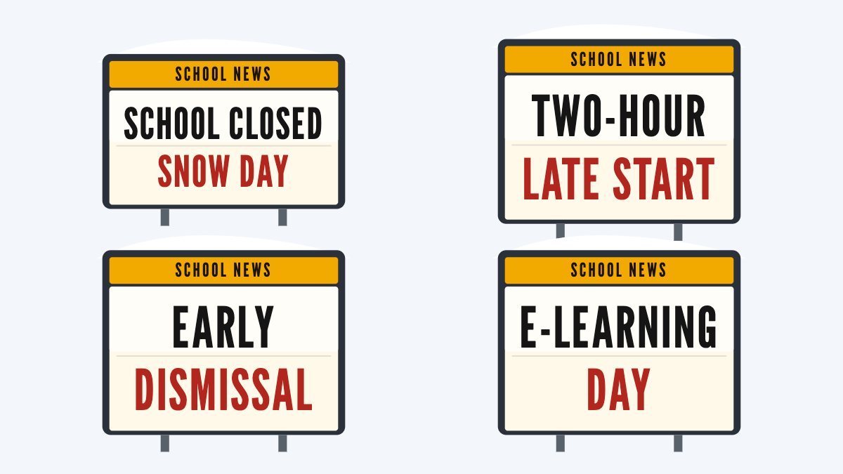
School news
Each office also sets its own timing. In the offices we read, the watch comes first: 36 to 48 hours ahead around Atlanta, 18 to 36 hours around Raleigh and 24 to 72 hours around Binghamton, New York. Raleigh issues a warning for a storm due in the next 12 to 24 hours, and Boston for one in the next 12 to 36. Around Baltimore and Washington, warnings average close to 24 hours of notice and advisories about 12 (NWS Baltimore/Washington).
How much snow does it take for a winter storm warning?
Anywhere from 2 inches to 10 in the six Weather Service offices whose pages we read. The national page says the snow needed for a warning in the Northern Plains is “typically much higher” than in the Southeast (winter alerts page). Each office’s own numbers:
- Atlanta area (Peachtree City office): a warning at 2 inches of snow, half an inch of sleet or a quarter inch of freezing rain; an advisory, 12 to 24 hours ahead, for lesser trouble (NWS Peachtree City).
- Raleigh: a warning at 3 inches in 12 hours or 4 in 24, averaged over a county; an advisory at 1 inch in 12 hours or 3 in 24 (NWS Raleigh).
- Baltimore and Washington (Sterling, Virginia, office): a warning at 5 inches, 6 in six western counties; an advisory at 2 to 4 inches, or just 1 inch during the 4 to 9 AM or 2 to 7 PM rush in the metro areas (NWS Baltimore/Washington).
- Boston (Norton office): a warning at 6 inches averaged over a forecast zone, 7 in the Berkshires; an advisory at 3 inches in 12 hours, or for any freezing rain on the roads (NWS Boston).
- Binghamton, New York: a warning at 7 inches in a storm in New York and 6 in northeast Pennsylvania (NWS Binghamton).
- Northern Michigan (Gaylord office): a warning at 8 inches in 12 hours or 10 in 24, less with strong winds; an advisory often for 3 to 8 inches (NWS Gaylord).
So the same 4 inches in 12 hours brings a warning around Atlanta and an advisory around Boston. If you move, learn your new office’s numbers.
Which winter alerts does the Weather Service issue now?
Its current list of alert types, the same set its hazards map uses, has these for snow, ice and cold:
- Warnings: Winter Storm, Blizzard, Ice Storm, Lake Effect Snow, Snow Squall and Extreme Cold.
- Watches: Winter Storm and Extreme Cold.
- Advisories: Winter Weather, Cold Weather and Freezing Fog.
A blizzard warning is about wind and visibility, not snow depth: frequent gusts of 35 mph or more with falling or blowing snow that keep visibility under a quarter mile for 3 hours or more. An ice storm warning usually means a quarter inch of ice or more (winter alerts page). From about October 1, 2026, both can carry Particularly Dangerous Situation wording (Service Change Notice 26-52).
The lake effect snow warning has come and gone. The Weather Service dropped it at every office from October 15, 2018 (notice 17-77), brought it back on October 1, 2019, as an option each region decides on (notice 19-63), and said in November 2023 that the Buffalo, Binghamton and Albany offices still issue it (notice 23-107). Elsewhere, lake effect snow can come under a winter storm warning.
Some names are gone. The wind chill alerts became the Extreme Cold Warning, Extreme Cold Watch and Cold Weather Advisory in October 2024 (NWS). The freezing rain and lake effect snow advisories were folded into the Winter Weather Advisory, and the blizzard and lake effect snow watches into the Winter Storm Watch (NWS Central Region).
Two more changes are on the way. A 2023 notice said advisories will be replaced by plain-language headlines (notice 23-49), but the Weather Service still lists that as upcoming (hazard simplification), and the Winter Weather Advisory is still issued. And a September 2026 notice says Lake Ontario is being renamed “Lake America” in Weather Service products, in phases (notice 26-69), so a lake effect alert may use either name.
What happened to the wind chill warning?
It became the Extreme Cold Warning on October 1, 2024. The same change turned the wind chill watch into the Extreme Cold Watch and the wind chill advisory into the Cold Weather Advisory (Service Change Notice 23-44). The reason, in the Weather Service’s words: cold “can be dangerous with or without wind” (NWS news release).
The cold alerts now go out on the temperature or the wind chill, with no wind threshold, as the Amarillo office explains (NWS Amarillo). An Extreme Cold Warning means extremely dangerous cold or wind chills are expected or happening; a watch means they are possible but the timing or place is still uncertain; a Cold Weather Advisory means dangerous cold below warning level (cold alerts page).
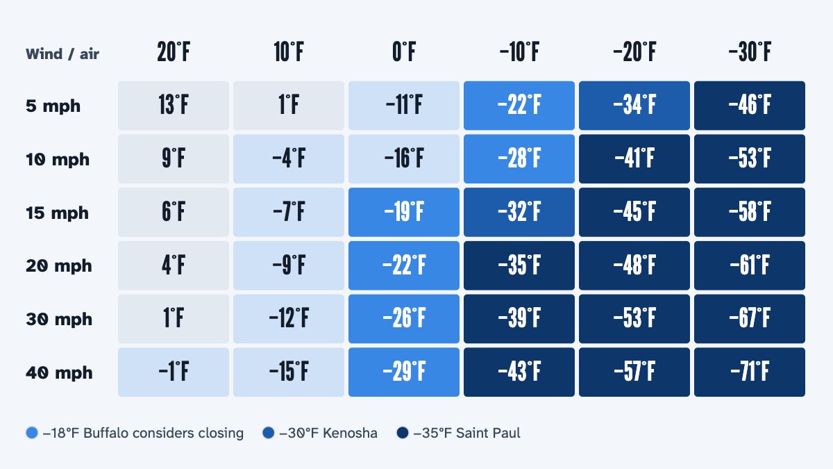
The numbers are local here too. Around Atlanta an Extreme Cold Warning comes at 0°F or lower and an advisory at 1°F to 10°F (NWS Peachtree City). In northeast Wisconsin the warning is −30°F or lower and the advisory below −20°F, as the Appleton school district quotes them (Appleton Area School District). Try the Weather Service’s wind chill formula below; our guide to cold-weather closings has more.
Wind chill at the bus stop
−19°F
0°F with a 15 mph wind feels like −19°F. Buffalo, New York, will consider closing at −18°F.
The formula is the National Weather Service's, from its wind chill chart. Its own example: 0°F with a 15 mph wind feels like −19°F, and exposed skin can freeze in 30 minutes.
How far ahead do warnings come, and how often are they right?
About a day ahead, and usually right, going by the Baltimore and Washington office, which publishes its own record. Its warnings for 5 inches or more average close to 24 hours of lead time, a significant storm gets a warning in advance more than 90% of the time, and storms of more than 12 inches often come with 3 to 6 days of notice (NWS Baltimore/Washington).
The other side of that record: about 1 in 3 of its warnings do not verify, many because real snow fell but less than warning size (same page). Storm tracks shift. Milwaukee Public Schools notes that a shift in a storm’s track can mean many inches of snow or just light snow or rain (MPS), and Kenosha’s policy says advance warnings “are often canceled due to a change in storm systems” (KUSD policy 3643).
So read a forecast as a range. The Twin Cities office’s experimental snowfall pages show the most likely amount next to a low end, with a 9 in 10 chance of more snow, and a high end, with a 1 in 10 chance of more (NWS Twin Cities). If even the low end tops the snow that usually closes your schools, that is a strong sign; if only the high end does, wait for the morning call.
Does a winter storm warning mean school is closed?
No. Only your district decides, and no alert closes schools on its own. Even NOAA’s Weather Prediction Center says a moderate rating on its Winter Storm Severity Index does not mean schools will or have to close (WSSI user guide).
Several districts name the alerts in their rules. Milwaukee lists the winter weather advisory, the winter storm watch and warning, and the cold alerts among what it watches (MPS). Kenosha weighs whether a warning is still in effect at or after 5 AM (KUSD). Chicago closed on January 23, 2026, under a Weather Service warning for wind chills that could reach −35°F (CPS), and Anoka-Hennepin, Minnesota, says closing is likely when an Extreme Cold Warning is issued (district Q&A).
The snow total still matters. In Joshua Goodman’s study of Massachusetts schools, days with 10 inches or more brought closures, while days with 4 to 10 inches mostly did not, though more students stayed home (NBER). Boston’s warning starts at 6 inches, inside that middle range.
In our calculator the big warnings raise the chance more than watches and advisories. A blizzard or ice storm warning counts most, then an extreme cold warning, then a winter storm or lake effect snow warning. Next come the winter storm and extreme cold watches, and a snow squall warning if it is in force between 5 and 9 AM; then the winter weather advisory, and the cold weather advisory least. Only the strongest alert in force from 6 PM the night before to 9 AM counts, and by our rule of thumb it is one input, next to the snow, ice and cold themselves. The exception is a blizzard or ice storm warning in force at any time from 5 to 9 AM: it keeps the calculator’s chance of a snow day at 65% or more (how it works).
Winter weather alerts
- Watch
- big storm possible
- often a day or more ahead
- time to plan
- Advisory
- trouble below warning level
- about 12 hours ahead near DC
- Warning
- significant storm expected
- about 24 hours ahead near DC
- travel difficult
- Cold alerts
- Extreme Cold Warning
- Extreme Cold Watch
- Cold Weather Advisory
- Set locally
- 2 inches near Atlanta
- 8 inches in 12 hours up north
- School
- your district decides
- big warnings weigh most in our rule
Questions people ask
Is a winter storm watch or warning worse?
A warning. Both are about a significant storm, but a watch means it is possible and a warning means it is expected; the Weather Service’s coded alerts label the watch as possible and the warning as likely (CAP message defaults).
Is a winter weather advisory serious?
It is below warning level, but it is about real travel trouble. Around Baltimore and Washington an advisory goes out for as little as 1 inch of snow during the morning or evening rush (NWS Baltimore/Washington), and around Boston for any freezing rain on the roads (NWS Boston).
How many inches of snow is a winter storm warning?
It depends on your Weather Service office. In the six offices we read, it ranges from 2 inches around Atlanta to 8 inches in 12 hours, or 10 in 24, in northern Michigan.
Is there still a wind chill warning?
No. Since October 1, 2024, the Weather Service issues an Extreme Cold Warning, Extreme Cold Watch or Cold Weather Advisory instead, based on the temperature or the wind chill (Service Change Notice 23-44). Older pages and some school policies still use the old names.
What is a blizzard warning?
A warning for wind and blowing snow rather than snow depth: frequent gusts of 35 mph or more with falling or blowing snow that keep visibility under a quarter mile for 3 hours or more (winter alerts page). In our calculator it counts as much as an ice storm warning, more than any other alert, and one in force between 5 and 9 AM keeps the chance of a snow day at 65% or more.
Sources: National Weather Service, winter watches, warnings and advisories; National Weather Service, cold watches, warnings and advisories; NWS Baltimore/Washington, snow warnings and lead times.
Facts checked October 29, 2026.
More guides
-
-
-
-
-